It is a crucial route for local communities and businesses that provides connectivity between Wolverhampton City Centre and Tettenhall stretching into South Staffordshire.
Improvements are needed to address safety and traffic congestion, particularly during peak times. The proposed changes at the junction will work to improve, journey time reliability, safety for drivers, pedestrians and cyclists and air quality.
A consultation was held on proposed changes at the busy junction and 291 people took part reflecting a wide range of opinions from across the community. Now the council will take time to analyse the feedback as well as involving partners, including West Midlands Police. It will also seek the opinion of independent traffic management experts before making a final decision.
The information provided outlines the consideration of the implementation of measures at the following locations:
- Tettenhall Road / The Rock / Lower Street / Henwood Road
- Stockwell Road area
- Upper Green
- Keepers Lane
Key issues
The junction of Tettenhall Road / Henwood Road is severely constrained by level differences on all approaches, limited footways, and restricted land availability on 3 sides. Options to improve pedestrian and cyclist facilities, widen footways and reduce vehicle conflicts within the junction area have been considered over the past 10 years. Targeted lane widening, and signal technology enhancements have been implemented and now ensure the efficiency of the signals is maximised given the footprint available.
Currently the traffic signal timings are managed using an adaptive signal control strategy (SCOOT). SCOOT works to balance queuing traffic on all approaches whilst prioritising the priority route (A41). To achieve this, it continuously measures the approaching traffic and calculates the junction cycle time, along with the green time for each approach and makes the necessary changes for every cycle of the junction. Despite this, significant queues and delays are experienced, particularly on Lower Street and Henwood Road during peak demand periods.
A further problem with the operation of the junction is the restricted forward visibility and narrow width of the approaches from Lower Street and Henwood Road. This means that vehicles turning across traffic often block the lanes and restrict straight over movements, resulting in further queues and delays and on occasion inappropriate and unsafe driving behaviours.
Following this review the key issues have been summarised below:
- The junction is ranked second worst performing in terms of collision history in Wolverhampton. This was also highlighted in the annual review of traffic collisions undertaken as part of the councils’ statutory duties.
- 12 personal injury collisions in the previous 5 years.
- Seven collisions attributed to vehicles turning right at the junction.
- Three collisions recorded from Lower Street and three collisions recorded from Henwood Rd
- The junction is a pinch point on one of the City’s Key Route Network and suffers significant congestion at peak traffic times.
- Pedestrian facilities located between 100-200m from the junction are not synchronised with the signals at the junction.
- The bus stop located on A41 (Tettenhall Rd) south of the junction causes delay to traffic travelling inbound during peak traffic times.
Options
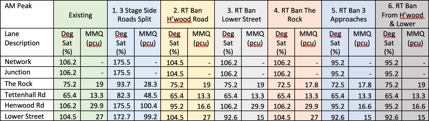
Following a detailed study of the junction, traffic modelling was undertaken to assess the following options.
- Introduce a 3rd stage allowing for Henwood Road and Lower Street to operate independently.
- Right turn ban from Henwood Road.
- Right turn ban from Lower Street.
- Right turn ban from The Rock.
- Right turn ban from Henwood Road, Lower Street and The Rock.
- Right turn ban from Henwood Road and Lower Street.
- Early cut off Lower Street allowing Henwood Rd right turn unopposed.
- Controlled pedestrian crossing across Lower Street.
- Right turn ban from Henwood Road and Lower Street with controlled pedestrian crossing across Lower Street and The Rock.
![]()
Details of the traffic movements used in this assessment was based on detailed traffic surveys undertaken during January 2023, which are consistent with typical flows through the junction.
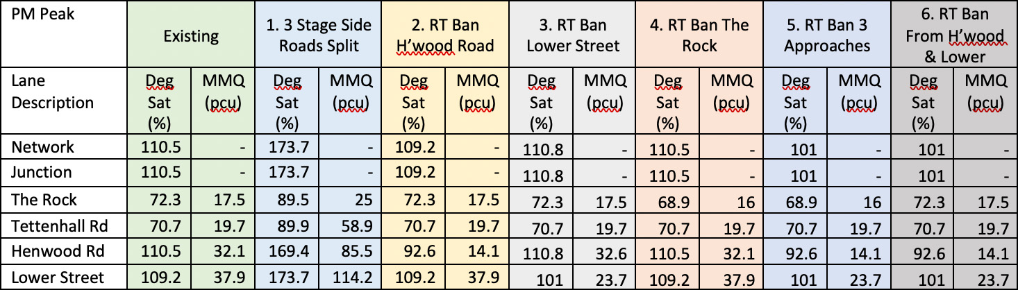
Modelling Results - Option 1 to 6, summary of traffic modelling results.
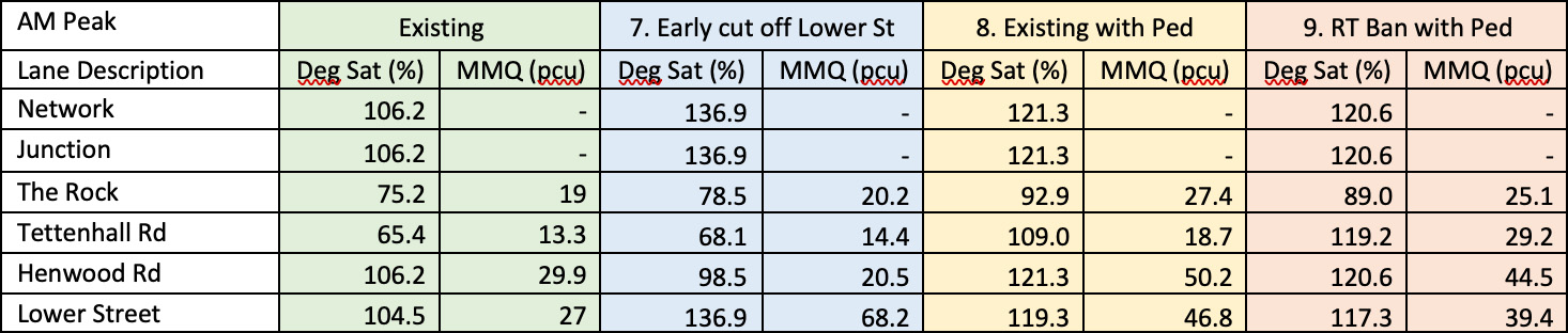
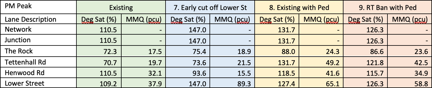
Option 7 to 9, summary of traffic modelling results.
Summarising the results of the options:
Operating Henwood Road and Lower Street traffic signals independently causes noticeable degradation in the operation of the junction; with the saturation of the junction being hugely increased, approximately 60 per cent, and queue lengths significantly increased on all approaches, but typically 300 per cent on both Henwood Rd and Lower Street, leading to average queue lengths of more than 500m at peak times.
Banning individual right turn movements benefits each specific approach, however, it can be clearly seen that Option 6 - banning the right turn movements from Henwood Road and Lower Street, provides the most significant benefits to the operation of the junction over the existing situation. This option improves the operation of the junction, resulting in a typical 50 per cent reduction in average queue lengths along Henwood Rd and Lower Street, without any impact on the main road during AM and PM peak periods.
Traffic modelling indicates that Option 7, the provision of an early cut off on Lower Street to provide a right turn indicative arrow on Henwood Road will benefit Henwood Road, however it will have a severe negative impact on queue lengths on Lower Street. AM and PM peak modelling results show that there will be an increase in queue length on Lower Street of approximately 250 per cent leading to average queue lengths of 500m at peak times.
Options have been assessed for the provision of pedestrian facilities at the junction of Henwood Road / Lower Street. Due to constrained footway widths on the southwest corner of the junction, it is not feasible to install pedestrian facilities across Tettenhall Road or Henwood Road within the existing constraints of the junction.
Modelling of Option 8 indicates that the provision of pedestrian facilities across Lower Street and The Rock, while maintaining all turning manoeuvres, will have a severe negative impact on vehicle flow and queue lengths. Data shows that there will be an increase in overall queue length of 170 per cent. This will lead to queue lengths more than 270m on Tettenhall Road Out Bound and 350m on Lower Street.
Modelling of Option 9 indicates that the provision of pedestrian facilities across Lower Street and The Rock, including the ban of right turn movements from Lower Street and Henwood Road, will have a severe negative impact on vehicle flow and queue lengths. Data shows that there will be an increase in overall queue length of 150 per cent. This will lead to queue lengths of more than 230m on Tettenhall Road OB and 320m on Lower Street.
Within the detailed modelling and on street observations, it was also identified that there was potential for exit blocking, caused by the ad-hoc operation of nearby pedestrian crossing facilities. Furthermore, it was also observed that the bus stop, located on the southeast side of the junction, also impacted on traffic travelling through the junction creating additional delay.
Recommendations
Following the review, it has been determined:
- The collision rate experienced at the junction is high when compared with other locations across the city with a prevalence of right turning collisions. Therefore, doing nothing is not an option.
- To consult on the proposals below being implemented as an experimental Traffic Regulation Order, which will allow the changes to be implemented and monitored over an initial period of up to 18 months, before deciding whether to make them permanent (Objections to be made in the first six months of operation).
- Although not a strict legal requirement there is a period of consultation that has commenced in order to capture and consider any material concerns.
The proposal comprises the following measures:
The Rock Junction
See Appendix C – Works associated with Tettenhall Road / Henwood Road Junction
- Implement a right turn ban for traffic approaching from
- Henwood Rd (See Appendix A for alternate route)
- Lower Street (See Appendix B for alternate route).
- Direction signs will be reviewed and updated on the approaches to the junction and the surrounding area to reflect the changes.
- The road markings on Tettenhall Rd outbound will be remarked in two lanes, the nearside lane will be ahead and left and the offside lane will be right turn only (formalising what currently happens on site).
- Closely associated pedestrian facilities will be configured to operate in synchronisation with the junction.
- A new ‘KEEP CLEAR’ marking will be introduced at the junction of Tettenhall Road / Newbridge Crescent.
- The location of the existing CCTV will be reviewed to support the ongoing monitoring of the junction.
- Relocate the bus stop to the southeast of the junction to reduce risk of queuing traffic backing through the junction.
Stockwell Road area and Upper Green
See Appendix D – Consultation Drawings One Way TRO and parking restrictions
- Implement one way system to control traffic flows and address complaints regarding traffic congestion in Stockwell Road and Malthouse Lane.
- Simplify traffic conflict at the junction of The Rock/Stockwell Road as Upper Green becomes one way, hence improving safety.
- Allows the creation of additional parking along Upper Green to support access for the local village centre
Keepers Lane
See Appendix E – Briefing Note Keepers Lane
Introduction of a 20mph speed zone including;
- 20mph terminal signs at the junction A41 and extended to the limits of the Wolverhampton Staffordshire border 300m to the north.
- White lining to create narrowing feature at the entry point to Wolverhampton from the north with Dragons Teeth carriageway markings
- Dragons Teeth carriageway markings at the point of entry from the junction with the A41
- Installation of vertical traffic calming measures ‘Thump’ (900mm long and approximately 40-45mm high with a round top profile), at an approximate distance of 80m between measures.
The intention of these interventions outlined above is to reduce the number of road traffic collisions resulting in personal injury along with improving the congestion that is experienced by road users travelling through the junction.
Appendices*
Appendix A – Alternate Route identified due to the implement a right turn ban for traffic approaching from Henwood Rd
Appendix B – Alternate Route identified due to the implement a right turn ban for traffic approaching from Lower Street
Appendix C – Works associated with Tettenhall Road / Henwood Road Junction including No Right Turn TRO from Henwood Road and Lower Street.
Appendix D – Consultation Drawings One Way and Parking Restrictions, Stockwell Road area & Upper Green
Appendix E – Keepers Lane Briefing Note
*Accessible via the Downloads section of this page.
Keepers Lane – Traffic calming
Following preliminary investigations of the proposed scheme at The Rock junction, which proposes to restrict right turn movements from Henwood Road and Lower Street to the A41, it has been highlighted that Keepers Lane is a potential diversion route for vehicular traffic wishing to avoid the proposed restrictions.
Keepers Lane is located to the northwest of Wolverhampton providing a convenient alternative route between Codsall in Staffordshire and the A41 in Wolverhampton.
It has been agreed to consider the introduction of suitable traffic calming measures to assist in reducing vehicle speeds and discourage an increase in traffic flow.
Key Issues Identified
The length of Keepers Lane within Wolverhampton is approximately 300m in length before entering Staffordshire to the north. The route is subject to a 30mph speed limit from its junction with the A41 in a northerly direction for 220m at which point it becomes subject to the national speed limit.
The average carriageway width is less than 5m and a single footway is provided on its east side for a distance of 150m from the junction with the A41.
Residents of Keepers Lane have previously raised concerns regarding speed and increased numbers of HGVs. Following an investigation in 2018, the Road Safety team implemented the following measures:
- Extended the environmental weight limit from the boundary of Staffordshire along its length to the A41.
- Installed new yellow backed 30mph speed limit signs.
Following our current review, the key findings have been summarised below;
- Road traffic injury collision data, provided by West Midlands Police, indicate that there have not been any recorded instances of collisions resulting in injury on Keepers Lane in the previous 5 years.
An automated traffic count device was installed on Keepers Lane in February 2023 and provided the following summary of information;
|
Direction |
Start Date |
End Date |
Posted Speed Limit (PSL) |
Mean Speed |
85%ile Speed |
(24 Hour) 5 Day Ave |
(24 Hour) 7 Day Ave |
%age HGVs |
|
Northbound |
Fri 10 Feb 2023 |
Thu 16 Feb 2023 |
30mph |
26.2 |
31.8 |
1666 |
1484 |
0.11% |
|
Southbound |
Fri 10 Feb 2023 |
Thu 16 Feb 2023 |
30mph |
24.5 |
30.4 |
2149 |
1909 |
0.08% |
- The above information indicates general compliance with the posted 30mph speed limit.
- The reported flows indicate a level of use in keeping with this type of road with links to residential areas. HGV volume is minimal indicating compliance with the environmental weight restriction, except for access.
Options
Various traffic calming measures have been considered including speed cushions and priority give way with carriageway narrowing, however, due to the narrow width of the existing carriageway these options have been discounted as they cannot be accommodated within the prevailing geometry.
Despite this, three options were considered as they are most likely to provide resolution to the issues identified. The preferred option being Option 2.
Option 1
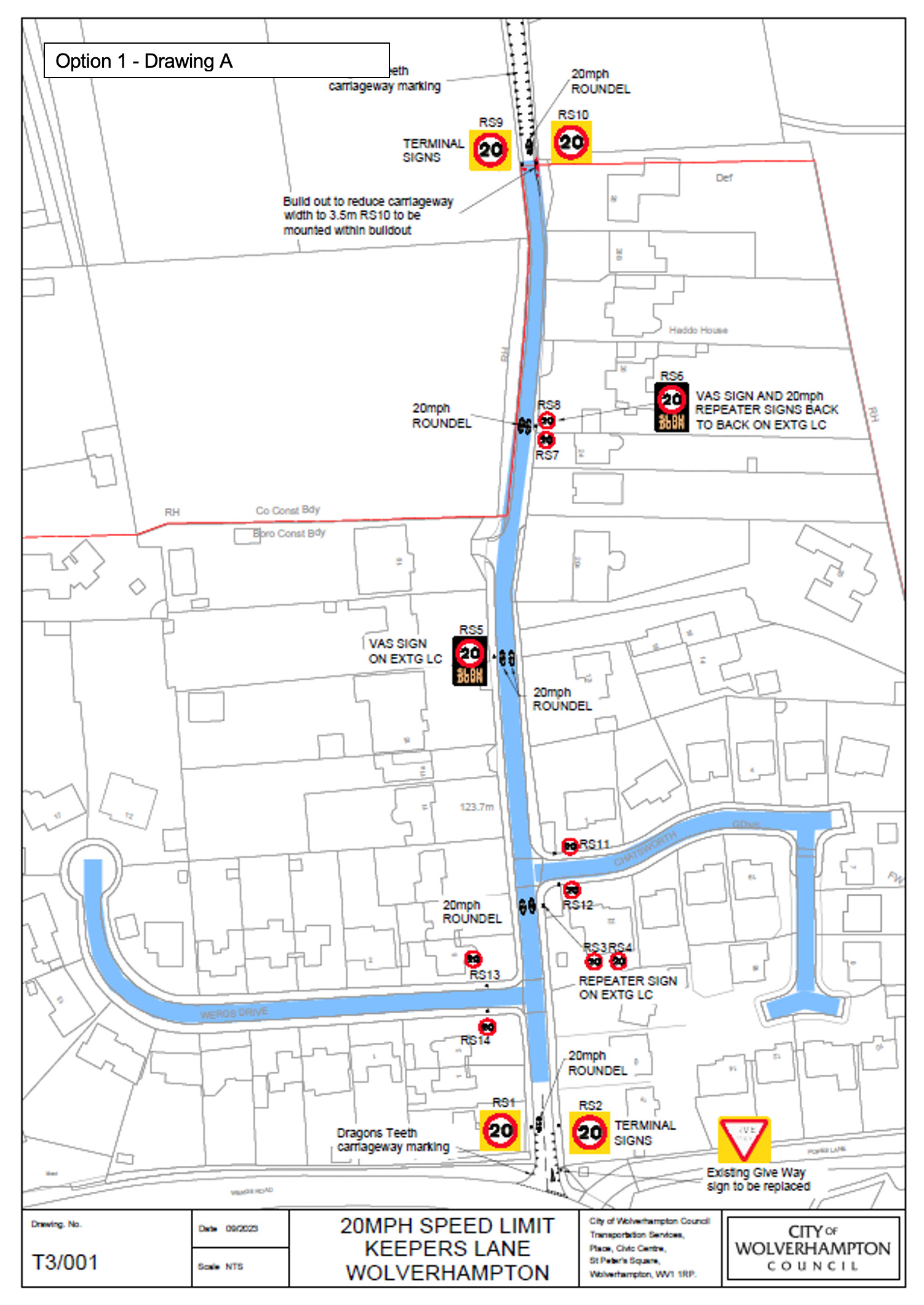
20mph Speed Limit - Drawing A
Introduction of a 20mph speed limit including;
- 20mph terminal signs at the junction A41 and extended to the limits of the Wolverhampton Staffordshire boarder 300m to the north.
- Build out to provide narrowing feature at the entry point to Wolverhampton from the north with Dragon’s Teeth carriageway markings.
- Dragon’s Teeth carriageway markings at the point of entry from the junction with the A41
- 20mph repeater signs at intervals in line with national guidance.
- 20mph repeater signs will also be installed at Chatsworth Gardens and Wergs Drive.
- Installation of 2no. VAS signs that will flash the speed limit and a slowdown message, acting as a visual deterrent for speeding motorists.
- Build out to provide narrowing feature at the northern limit of the Wolverhampton boundary.
Research into signed-only 20 mph speed limits shows that they generally lead to small reductions in traffic speeds. Signed-only 20 mph speed limits are therefore most appropriate for areas where vehicle speeds are already low. If the 85th%ile speed is already at or below 24 mph on a road, introducing a 20mph speed limit through signing alone is likely to lead to general compliance with the new speed limit.
Vehicle activated signs are also effective in reducing the mean speeds along a route as they are visual reminder to drivers travelling more than the posted limit. The effectiveness of permanent VAS signs is proven to reduce over time.
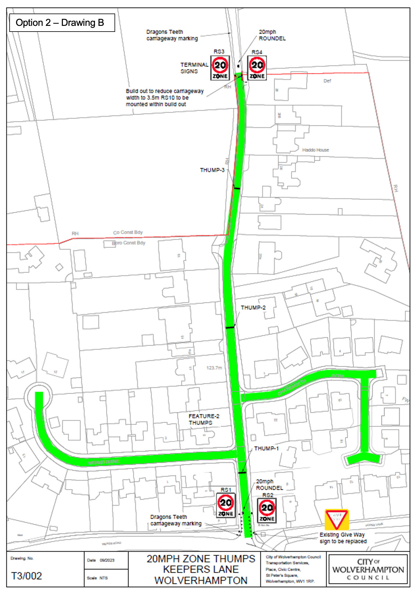
Option 2
20mph Speed Zone Drawing B
Introduction of a 20mph speed zone including;
- 20mph terminal signs at the junction A41 and extended to the limits of the Wolverhampton Staffordshire border 300m to the north.
- White lining to create narrowing feature at the entry point to Wolverhampton from the north with Dragon’s Teeth carriageway markings.
- Dragon’s Teeth carriageway markings at the point of entry from the junction with the A41
- Installation of vertical traffic calming measures ‘Thump’ (900mm long and approximately 40-45mm high with a round top profile), at an approximate distance of 80m between measures.
Road humps are a proven speed control device used in 20 mph zones and on 30 mph roads resulting in reductions in injury accidents of about 60 per cent.
The use of humps has been proven to reduce traffic flows on average by 25 per cent.
Option 3
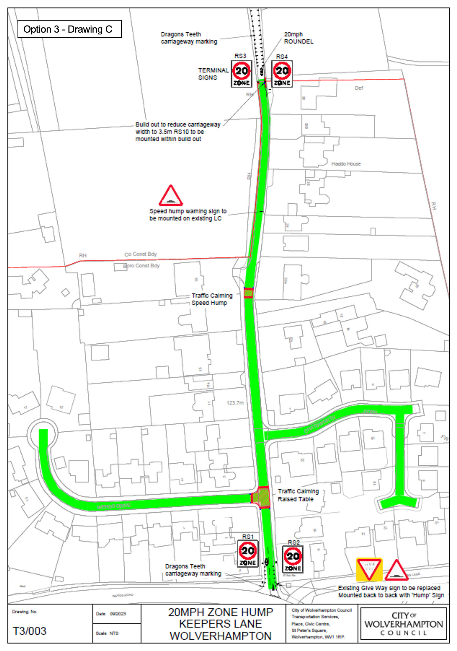
20mph Speed Zone Drawing C
Introduction of a 20mph speed zone including;
- 20mph terminal signs at the junction A41 and extended to the limits of the Wolverhampton Staffordshire border 300m to the north.
- Carriageway markings to provide narrowing feature at the entry point to Wolverhampton from the north with Dragon’s Teeth carriageway markings
- Dragon’s Teeth carriageway markings at the point of entry from the junction with the A41
- Installation of vertical traffic calming measures;
- Junction table at the junction of Keepers Lane / Wergs Drive,
- Road Hump located near no.17 Keepers Lane.
Recommendation
It is recommended that Option 2 is the preferred option as it is a cost-effective solution that balances the compliance with the proposed 20mph speed limit through the provision of vertical traffic calming measures with the potential deterrent to increased vehicular flows.